Trail Walking Kell Grañ - Saint Amadour - La Selle Craonnaise - Photo

Saint Amadour - La Selle Craonnaise

 tracegps
tracegps

User

© OpenStreetMap contributors
Length
Length
8.8 km
Max alt
Max alt
106 m
Uphill gradient
Uphill gradient
111 m
Km-Effort
Km-Effort  
10.3 km
Min alt
Min alt
62 m
Downhill gradient
Downhill gradient
110 m
Boucle
Boucle
Yes
Creation date :
2014-12-10 00:00:00.0
Updated on :
2014-12-10 00:00:00.0

(0 Reviews)

Walking
Walking
2h00
Difficulty : Medium

Scan this QR Code to open this trail in the SityTrail application

FREE GPS app for hiking

Logo SityTrail SityTrail

IGN / Geographical institutes

Download SityTrail from the App Store Download SityTrail from Google Play

Logo SityTrail SityTrail World

The world is yours!

Download SityTrail from the App Store Download SityTrail from Google Play Download SityTrail on Huawei AppGallery

About

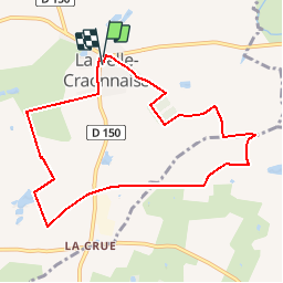
Trail Walking of 8.8 km to be discovered at Pays de la Loire, Mayenne, Kell Grañ. This trail is proposed by tracegps.

Description

Départ : place de l'église. Circuit très agréable, très peu de goudron, on arrive au château, nous le contournons dans un cadre agréable et l'on trouve des petits cyclamens sauvages. Sans trop de bruit on peut rencontrer des biches, attention au lieu dit l'Oriere, petit sentier mais balisé. Puis nous rattrapons l'ancienne voie de chemin de fer de la Mayenne, nous passons d'ailleurs devant l'ancienne gare désaffectée.

Elevation profile

Photos

Positioning

Country:
France
Region :
Pays de la Loire
Department/Province :
Mayenne
Municipality :
Kell Grañ
Location:
Unknown
Start:(UTM)
646415 ; 5300678 (30T) N.

Trails nearby

Trail Walking Kell Grañ - La Selle Craonnaise - Photo
Walking
neoroll44

Walking

Easy
Kell Grañ, Pays de la Loire, Mayenne, France
10.9 km | 12.7 km-effort
2h 45min
Yes
Trail Walking Niafles - niafles 2  - Photo
Walking
piquet

Walking

Difficult
Niafles, Pays de la Loire, Mayenne, France
14.2 km | 16.2 km-effort
3h 22min
Yes
Trail Coupling Kell Grañ - attelage  - Photo
Coupling
cavaleriedumoulin

Coupling

Very easy
Kell Grañ, Pays de la Loire, Mayenne, France
9.8 km | 11.4 km-effort
1h 43min
Yes
Trail Coupling Kell Grañ - attelage croix rouge 4 - Photo
Coupling
cavaleriedumoulin

Coupling

Very easy
Kell Grañ, Pays de la Loire, Mayenne, France
7.4 km | 8.5 km-effort
1h 1min
No
Trail Coupling Kell Grañ - attelage tour3 croix rouge  - Photo
Coupling
cavaleriedumoulin

Coupling

Very easy
Kell Grañ, Pays de la Loire, Mayenne, France
8.8 km | 10.2 km-effort
1h 32min
Yes
Trail Coupling Kell Grañ - boucle attelage croix rouge 2 - Photo
Coupling
cavaleriedumoulin

Coupling

Very easy
Kell Grañ, Pays de la Loire, Mayenne, France
9.1 km | 10.3 km-effort
1h 26min
No


Close
My subscriptions